Article Overview: Best Hikes in Arches National Park
No place in the world can boast as dense a concentration of natural rock arches as southeastern Utah’s Arches National Park, set right on the doorstep of Moab and showcasing some incomparably gorgeous—and legitimately surreal—topography.
This landscape was perhaps most memorably celebrated in Southwestern author and self-proclaimed “desert rat” Edward Abbey’s 1968 classic, Desert Solitaire, partly based on his days rangering in what was then Arches National Monument. The monument was established in 1929; Arches was upgraded to national-park status in ‘72.
Arches has become significantly more popular since Abbey’s days, but even with the crowds, the slickrock contortions here—not just arches, mind you, but a splendiferous medley of spires, pillars, buttes, balanced rocks, alcoves, petrified dunes, and more—are as breathtaking as countryside comes.
All the more given the La Sal Mountains on the horizon, which rear well beyond 12,000 feet and for much of the year provide a rugged, snow-capped backdrop to the redrock formations.
True, Arches doesn’t have the gigantic backcountry of some of Utah’s other Colorado Plateau wildlands—including nearby Canyonlands National Park or Grand Staircase-Escalante National Monument—but it’s still a stellar place to hike, with a nice variety of trails suited to a wide range of parkgoers. Getting away from the pavement is highly recommended—and exactly what a certain grizzled old desert rat would advise you to do.

Best Hikes in Arches National Park
Table of Contents: Best Hikes in Arches National Park
Table of Contents: Best Hikes in Arches National Park
Timed Entry Permit at Arches
Arches National Park is one of growing number of national parks that require reservations of some kind. Entering Arches National Park requires a permit from early April to October. During this time you must have a timed entry permit in order to access the park. These permit tickets are released 3 months in ahead of time so be sure to grab yours before you go (an example – permits for all of August are released on May 1).
Further Reading: All the National Parks that Require Reservations (UPDATED)
Things to Know Before Visiting Arches National Park
- Entrance Fees: $30 vehicle OR if you plan to visit more National Parks within the next 12 months I suggest you go ahead and purchase the America the Beautiful Pass.
- Sunscreen: Use it. Lots of it. Especially this one.
- Guide Book: This is our go-to Arches guidebook.
- Map: This is our go-to Arches map.
- Hotel: This is our favorite hotel for Arches National Park.
- Visiting More National Parks: This is a fun National Parks Checklist Map we created that can be ordered to your house.
- Framed National Parks Map: We’re a sucker for maps, our framed national parks map is the best.
Top 12 Best Hikes in Arches National Park
Skyline Arch Trail
- Distance: 0.4 mile
- Difficulty: Easy
- Elevation Gain: 28 feet
- Time Required: ~20 minutes
Hiking the Skyline Arch Trail in Arches National Park
This no-sweat trail near the Devils Garden Campground, among the easiest hikes in Arches National Park, leads you up to the base of pretty Skyline Arch, which spans some 71 feet and has a height of 33.5 feet.
Fetching as it is—and there’s no shortage of fetching rock formations in this part of the world, to put it mildly—Skyline Arch is perhaps most notable for being one of the best-documented examples of arch-forming processes in real-time. Before 1940, the arch had a notably narrower opening. That year, a big chockstone-like boulder toppled out of the arch, about doubling the framed window in size. (You can see a before-and-after picture of Skyline Arch here.)
Just a short way down the trail (about 0.2 miles), you’ll see some of the rubble left over from that 1940 rockfall: a stark reminder, coupled with the “new-and-improved” Skyline Arch opening, of the geologic processes always at work—every single second—here in Arches National Park.
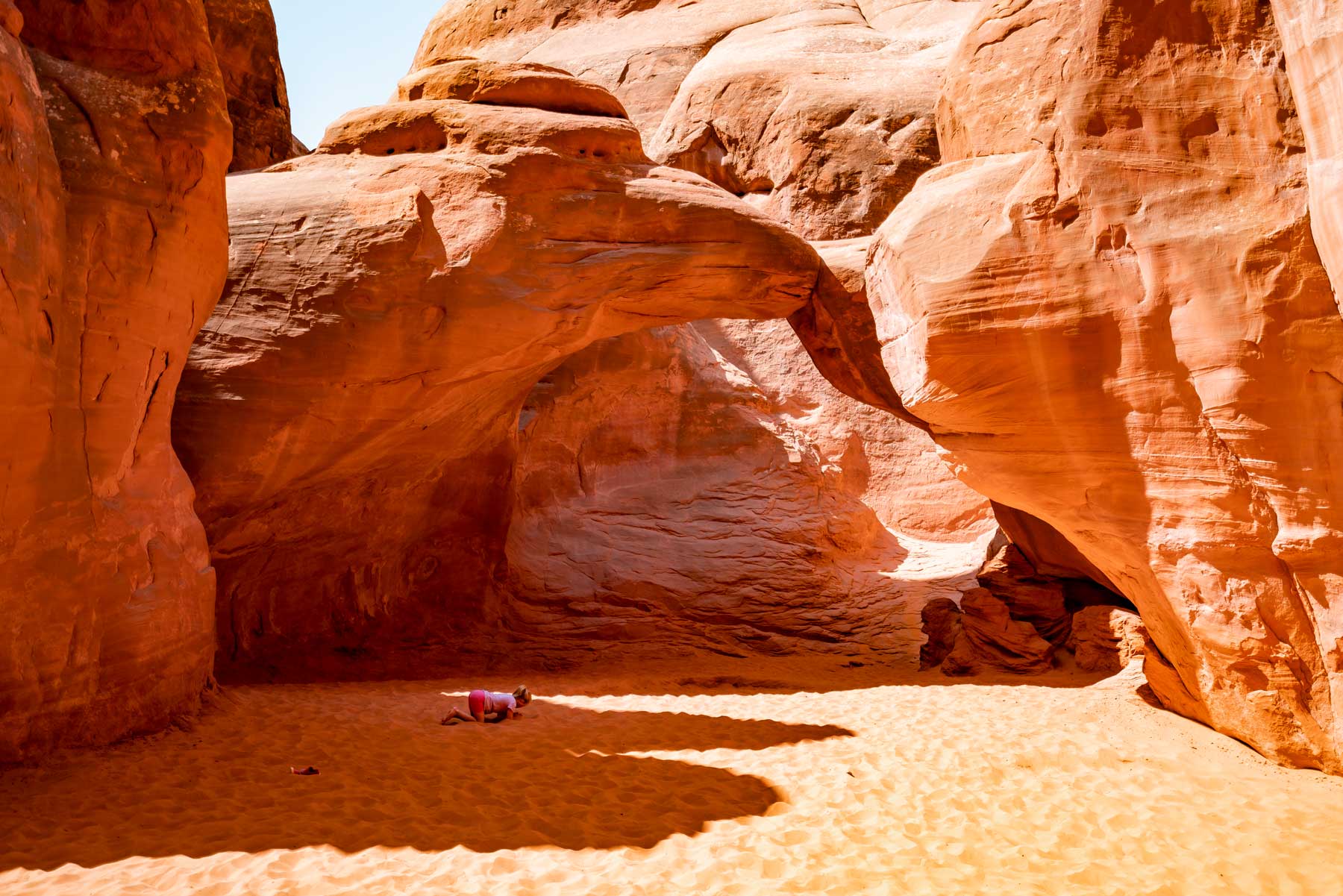
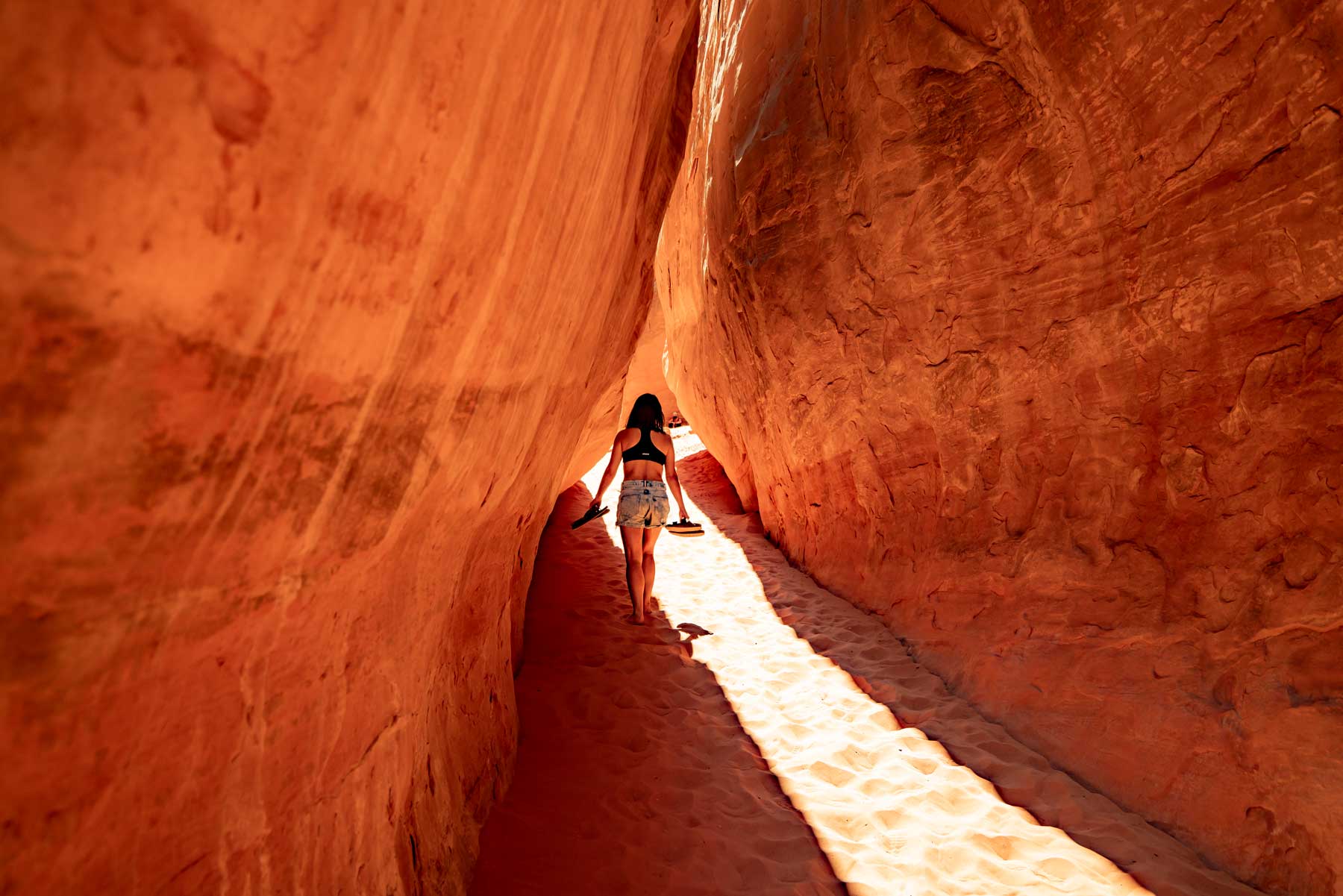
Broken Arch Loop & Sand Dune Arch
- Distance: 2.3 miles
- Difficulty: Moderate
- Elevation Gain: 59 feet
- Time Required: 1 hour
Hiking the Broken Arch Loop Trail in Arches National Park
Hiking in Arches National Park tends to treat you to a surfeit of landform astonishments. You can pay your respects to not one, not two, but three stellar arches on this lollipop loop beginning at the Sand Dune Arch Trailhead. In a mere 0.2 miles or so, you’ll come to Sand Dune Arch itself, sand-floored and tucked away amid sandstone walls.
Continue onward across a grassland flat—sometimes sprinkled with wildflowers, not uncommonly harboring a mule deer or two—to reach hefty Broken Arch, which stands nobly above a tract of pinyon-juniper woodland. Broken Arch isn’t, in fact, broken: It gets its name from the prominent crack down its lintel (the top, free-standing stone span of a natural arch).
A short ways past Broken Arch, you’ll come to a spur path toward the intriguing Tapestry Arch, backed against a sandstone wall and flanked on both sides by pseudo-arch alcoves. The rest of the hike involves looping through the Devils Garden Campground and then rejoining the approach trail back to the Sand Dune Arch Trailhead.
I like this as one of the best hikes in Arches National Park for families and people with wee ones as it’s really interactive and you can even hike to Sand Dune Arch barefoot (although I recommend at least sandals!).
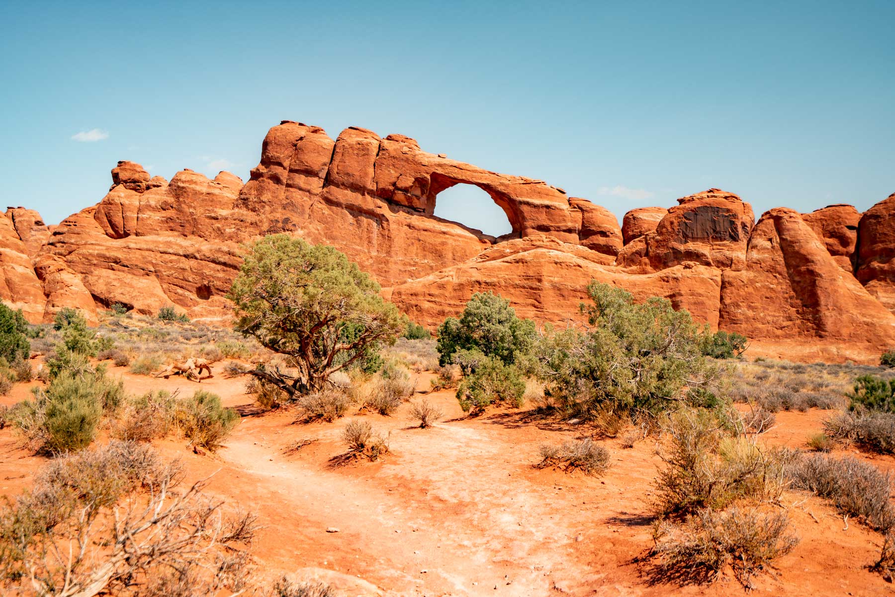
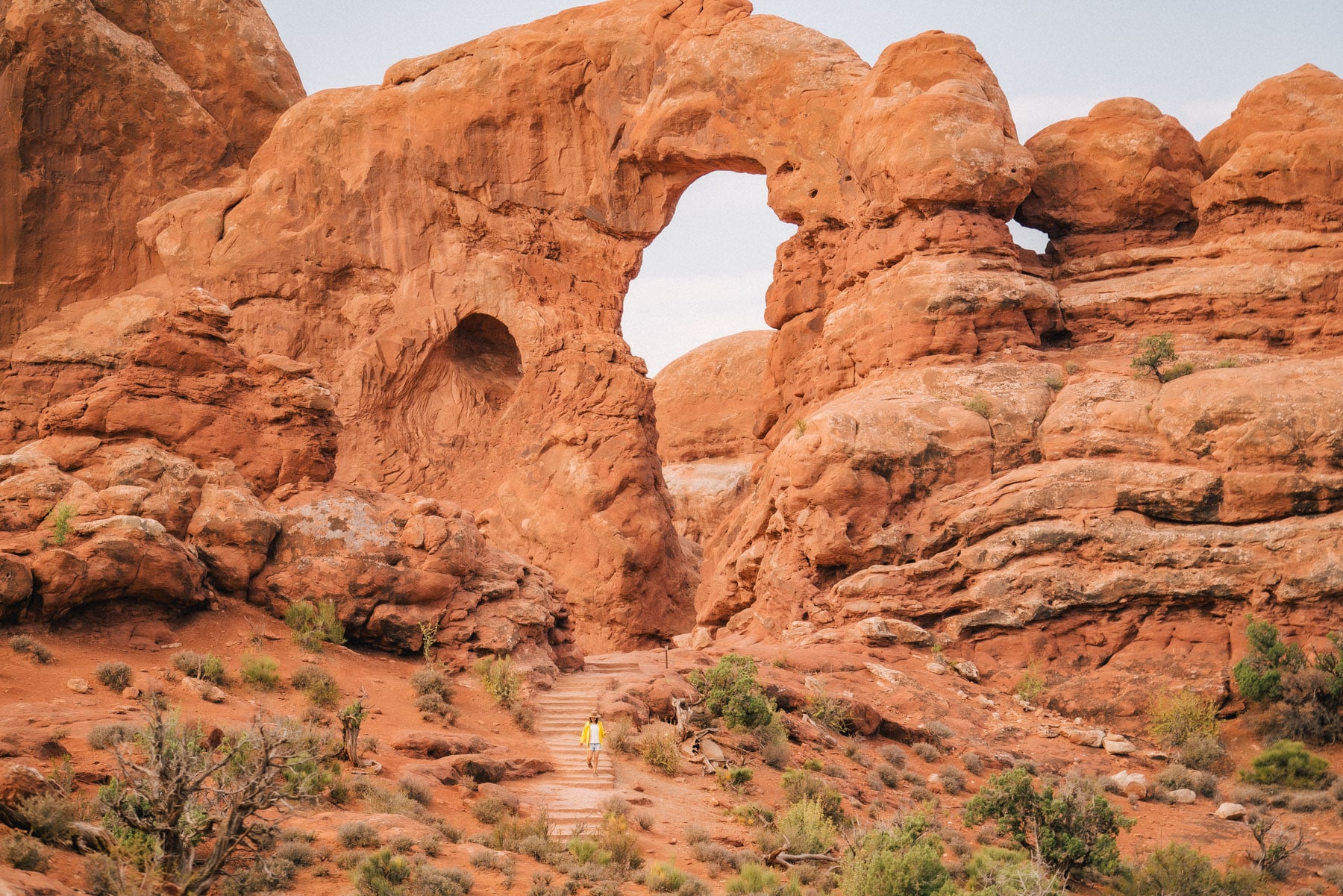
The Windows Loop
- Distance: 1 mile
- Difficulty: Easy
- Elevation Gain: 99 feet
- Time Required: 1 hour
Hiking the Windows Loop in Arches National Park
The Park Service calls the Windows Section “the beating heart of Arches National Park,” given its central position and evocative landscape. Certainly it’s one of the real lotta-bang-for-your-buck zones in a park that’s full of those. For these reasons many folks consider it the best hike in Arches National Park.
This easy loop (which can be easily combined with the hike to Double Arch, profiled below) introduces you to the strange and sublime scenery, which includes multiple arches and some long-range views across slickrock backcountry.
This part of the park is named for the Windows themselves: North and South Window, eroded out of the same prominent sandstone fin (an extension of sorts from the intricately gouged Elephant Butte complex to the immediate northwest). The Windows are also known as the Spectacles, on account from a southwestern vantage they line up like eyeglass lenses, complete with a “nose” of rock between them.
You can peer through North Window up the staggered rises of Dry Mesa and the Dome Plateau beyond. It’s also possible to look through Turret Arch, another arresting outcrop reached by a short spur along the loop that has a neighboring keyhole opening. South Window is handsome and elevated. All things considered, the Windows Loop is a pretty darn accessible introduction to the magic of hiking in Arches National Park.
Tower Arch (and the Marching Men)
- Distance: 2.6 miles
- Difficulty: Moderate – Strenuous
- Elevation Gain: 290 feet
- Time Required: 2-3 hours
Hiking to Tower Arch in Arches National Park
Set in the far northwest of Arches National Park, Tower Arch ranks among the most impressive arches in the area. It’s off-the-beaten-path location in the Klondike Bluffs puts it a little under the radar, though visitation (as everywhere in Arches) has certainly increased in recent years.
You’re looking at about eight miles of gravel road to reach the Tower Arch Trailhead, though the route’s accessible to passenger vehicles. The Klondike Bluffs area forms a dramatically scenic section of the rim along Salt Valley, one of the great dropped-down valleys (or grabens) that help form the spectacular landscape in this section of the Colorado Plateau. This vicinity offers some topnotch—and less-thronged—hikes in Arches National Park.
The trail to Tower Arch involves climbs and descents, including over slow-going sand, but the scenery from the get-go is stupendous, with remarkable sandstone fins and battlements in plain view. Just as impressive, really, as Tower Arch is the staggered cluster of tall, narrow spires known as the Marching Men, which rear southeast of the arch. Tower Arch, which spans 92 feet and rises to 42 feet tall, is so-named because of the burly, pale-topped pillar that looms close by.
Courthouse Wash Panel Trail
- Distance: 0.8 mile
- Difficulty: Easy
- Elevation Gain: 60 feet
- Time Required: Half-hour to an hour
Hiking the Courthouse Wash Panel Trail in Arches National Park
Just as evocative as the knockout geologic features in Arches are its signs of long-time human habitation. Hiking in Arches National Park can, after all, also be an exercise in history. And on that front it’s hard to beat the rock art on display on the Courthouse Wash Panel, a sandstone wall overlooking the confluence of south-running Courthouse Wash with the Colorado River. The site’s easily viewed by taking a short, easy path off U.S. 191 near the southern boundary of the park.
Bring a pair of binoculars for this walk: They’re ideal for viewing the pictographs (painted images) and petroglyphs (pecked or chipped images) of Courthouse Wash in greater detail. Archaeologists reckon the enigmatic tapered figures—an example of the so-called Barrier Canyon Style of indigenous Southwestern rock art—likely date between 1,500 and 4,000 years old, painted by Archaic-era peoples.
The Courthouse Wash Panel’s white shield-like images, meanwhile, may be a couple thousand years old—the work, perhaps, of Ancestral Puebloans or the Fremont Culture—or possibly more recent, perhaps added in historical times by the Paiute, Ute, or Navajo artists likely also responsible for figures shown on horseback.
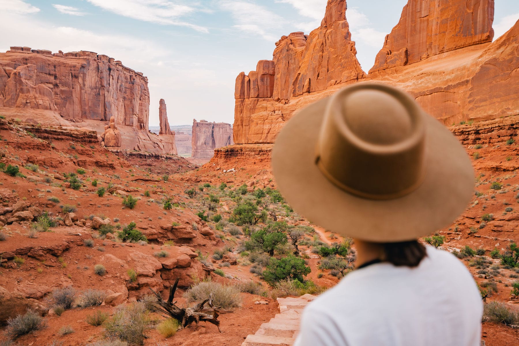
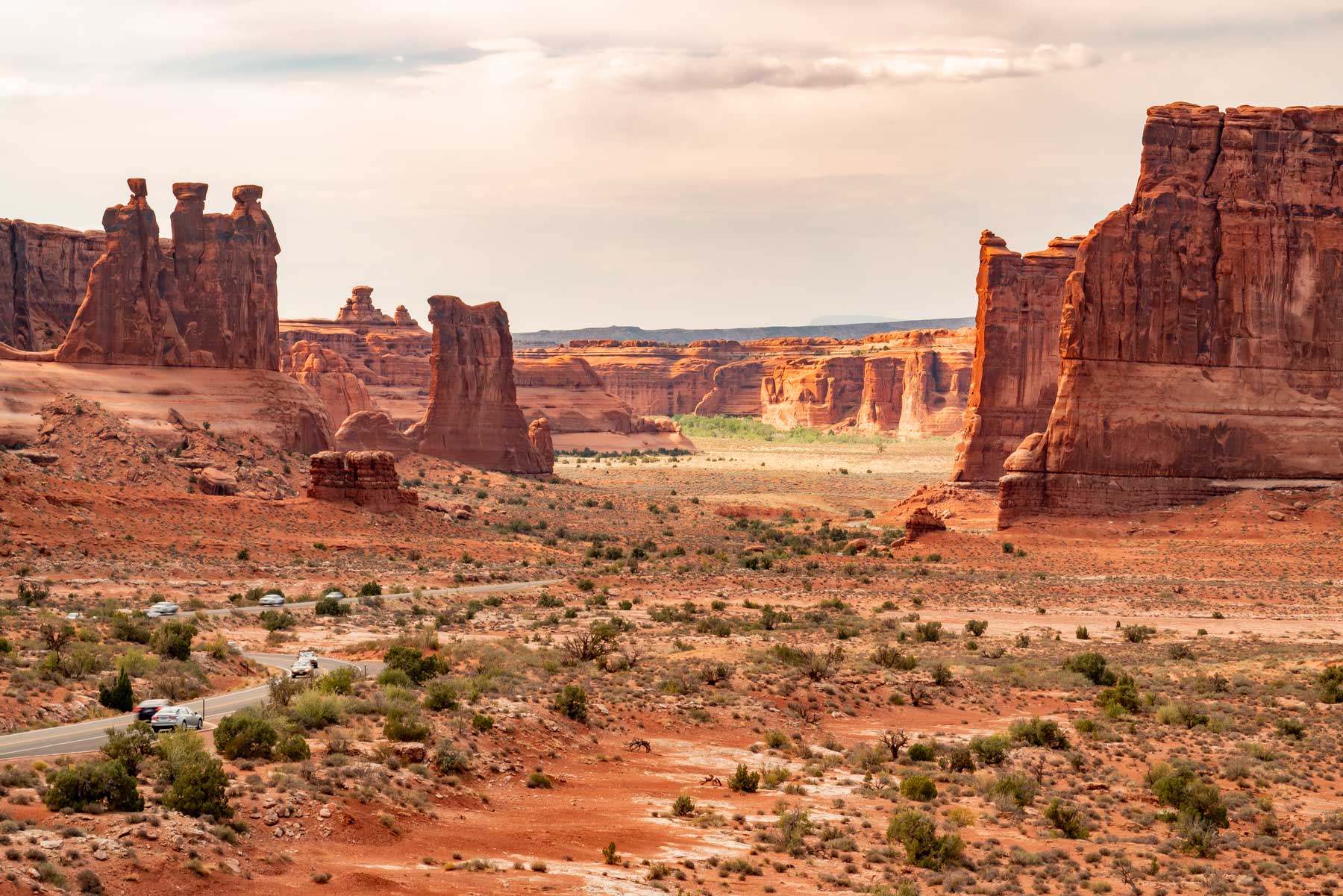
Park Avenue Trail
- Distance: 1.8 miles
- Difficulty: Moderate
- Elevation Gain: 322 feet
- Time Required: 1 hour
Hiking the Park Avenue Trail in Arches National Park
The Park Avenue Trail links the first two major scenic overlooks at Arches National Park coming in from the visitor center: the Park Avenue and Courthouse Towers viewpoints. While many travelers simply pull over and take in the vistas, it’s especially cool to walk your way between them, basking in some downright grand rockscapes.
For Indiana Jones fans like myself, this is one of two must adds to your list of best hikes in Arches National Park. This is where part of the intro horse scene was filmed in Last Crusade.
Given the trail’s not very long, a round-trip hike is very doable and worth it, though if you’re able to arrange a shuttle, you could just do this—among the best introductory hikes in Arches National Park—one-way.
Starting from the south trailhead—the Park Avenue Viewpoint—you’ll descend a stairway into the glorious corridor of Park Avenue: named for the resemblance of the surrounding sandstone eminences to Manhattan skyscrapers. (We think these are cooler, for the record.) Edging heights include Queen Nefertiti, Sausage Rock, Queen Victoria, and the Courthouse Towers themselves.
As you approach the Courthouse Towers Viewpoint, you can pick out the distinctive spire-huddle called the Three Gossips and the nascent arch forming in Baby Arch as well as the much-photographed Sheep Rock, Organ, and Tower of Babel. (Also: From the Park Avenue Viewpoint, try to spot the somewhat camouflaged Park Avenue Arch, positioned high up a rock wall to your right.)
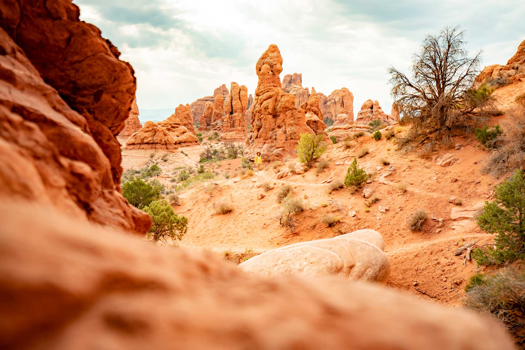
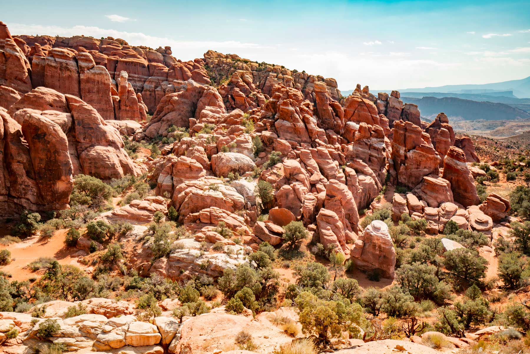
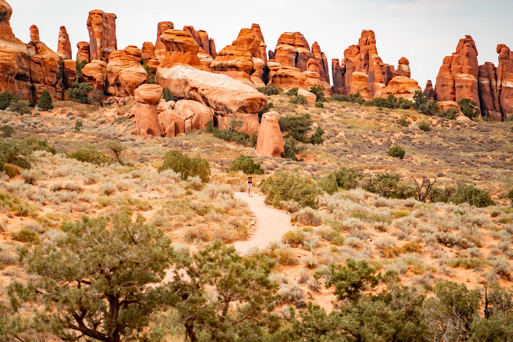
The Fiery Furnace
- Distance: 2 miles (for ranger-led hike)
- Difficulty: Difficult
- Elevation Gain: ~750 feet
- Time Required: 3 hours
Hiking the Fiery Furnace Trail in Arches National Park
Some of the best hiking in Arches National Park awaits in the Fiery Furnace, a complex scabland of fins, arches, domes, and pillars right off the main road in the north-central part of the park. It gets its name from the smoldering look of its sandstone bathed in low-angle sunlight; you’re liable to see more than a few folks taking in the sunset glow from the Fiery Furnace Viewpoint.
But you don’t have to restrict your appreciation for this remarkable outback from the viewpoint: You can strike off into its heart on foot!
Because of the labyrinthine nature of the Fiery Furnace—and because there’s plenty of precious groundcover scattered about the rocks to protect—the park limits the number of visitors who can enter it at a time, and requires they either join a ranger-led hike or explore independently with a Self-Guided Exploration permit.
If this is your first time visiting, it’s best to take the guided hike to acquaint yourself with this beautiful but bewildering maze. And don’t be too cocky: Even though it’s ranger-led, this outing demands some level of physical fitness and nerve, given the up-and-down, scrambling nature of the off-trail going and the fact that there are some steep drop-offs and squeeze-through passages along the way.
The scenic highlights are many, though: from Skull Arch, Crawl-Through Arch, and Surprise Arch to Walk-Through Bridge, one of the rare examples of a natural bridge—which spans a river, creekbed, or wash, unlike an arch—in Arches National Park.
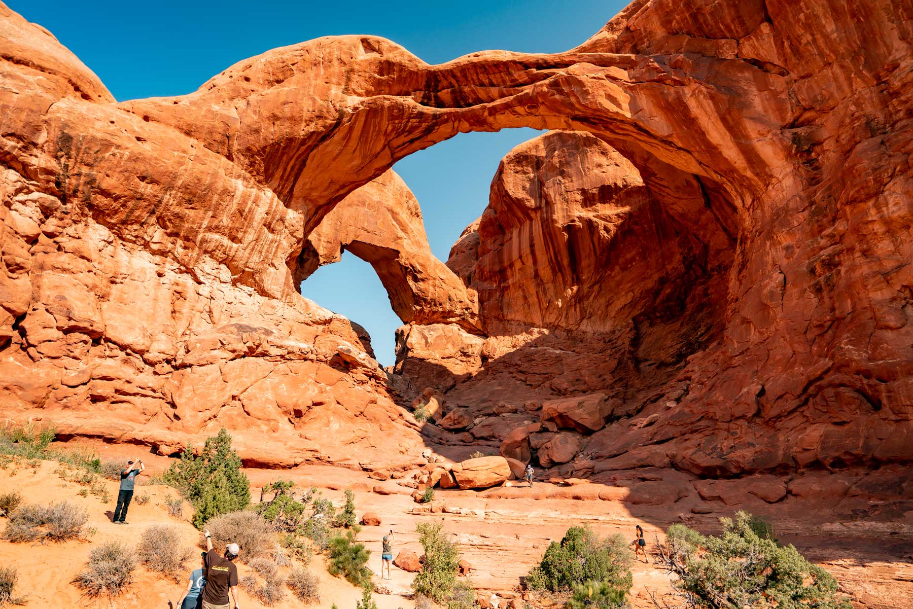
Double Arch Trail
- Distance: 0.6 mile
- Difficulty: Easy
- Elevation Gain: 30 feet
- Time Required: 15-30 minutes
Hiking the Double Arch Trail in Arches National Park
Massive Double Arch is one of the many scenic highlights of the centrally located Windows Section and among the best hikes in Arches National Park. At 112 feet, this is the tallest of the park’s arches; it’s also the second-longest, spanning 144 feet.
Is your Indiana Jones radar going off again? Mine is! This is where young Indy scrambles to find the Cross of Coronado in Last Crusade.
The name derives from its two mighty arms, forming paired arches converging at one end. It lies on the southern flanks of Elephant Butte, the high point of Arches National Park.
The very gentle grade and short length of this trail makes it doable for a wide range of parkgoers, and the scenic payoff isn’t just the close-up view of mighty Double Arch: You also enjoy sightlines across the fantastical Windows country, including to the lineup of keyholed knobs and pillars straggling south from Double Arch, known as the Parade of Elephants.
Eye of the Whale Arch
- Distance: 0.5 mile
- Difficulty: Easy
- Elevation Gain: ~50 feet
- Time Required: 20 minutes
Hiking the Eye of the Whale Arch Trail in Arches National Park
Needless to say, hiking in Arches National Park’s lesser-known corners can be a reward in and of itself. If you’d like to ditch the crowds and see one of the lower-profile Arches wonderlands—and if you’ve got a high-clearance vehicle—consider the short ramble to Eye of the Whale Arch in the park’s western hinterland.
This aptly named opening is a natural gateway to the ravine-gouged uplift of fins and pillars known as Herdina Park, which has plenty else to offer the adventurous hiker.
Just about any passenger vehicle can get to the start of the jeep trail accessing Eye of the Whale and Herdina Park. It breaks off the Willow Flats Road—the old entrance route to what was originally designated Arches National Monument—about three-quarters of a mile west of the main park road.
Following the 4WD jeep track about two miles northwest brings you to the signed Eye of the Whale trailhead. (If you’re not confident in your vehicle on this jeep trail, you could of course walk it, adding about four miles round-trip to your hike.)
The Eye of the Whale is visible from the trailhead parking area, and doesn’t necessarily look bowl-you-over impressive. But once you walk through this 12-foot-high gap and see it from the other side, the origin of its name becomes clear: It does indeed look something like the lidded peeper of a leviathan.
The view beyond Herdina Park is impressive as well—and will call to hikers prepared for backcountry navigation. This is a great addition to a list of best hikes in Arches National Park for folks who have been here before I’d say.
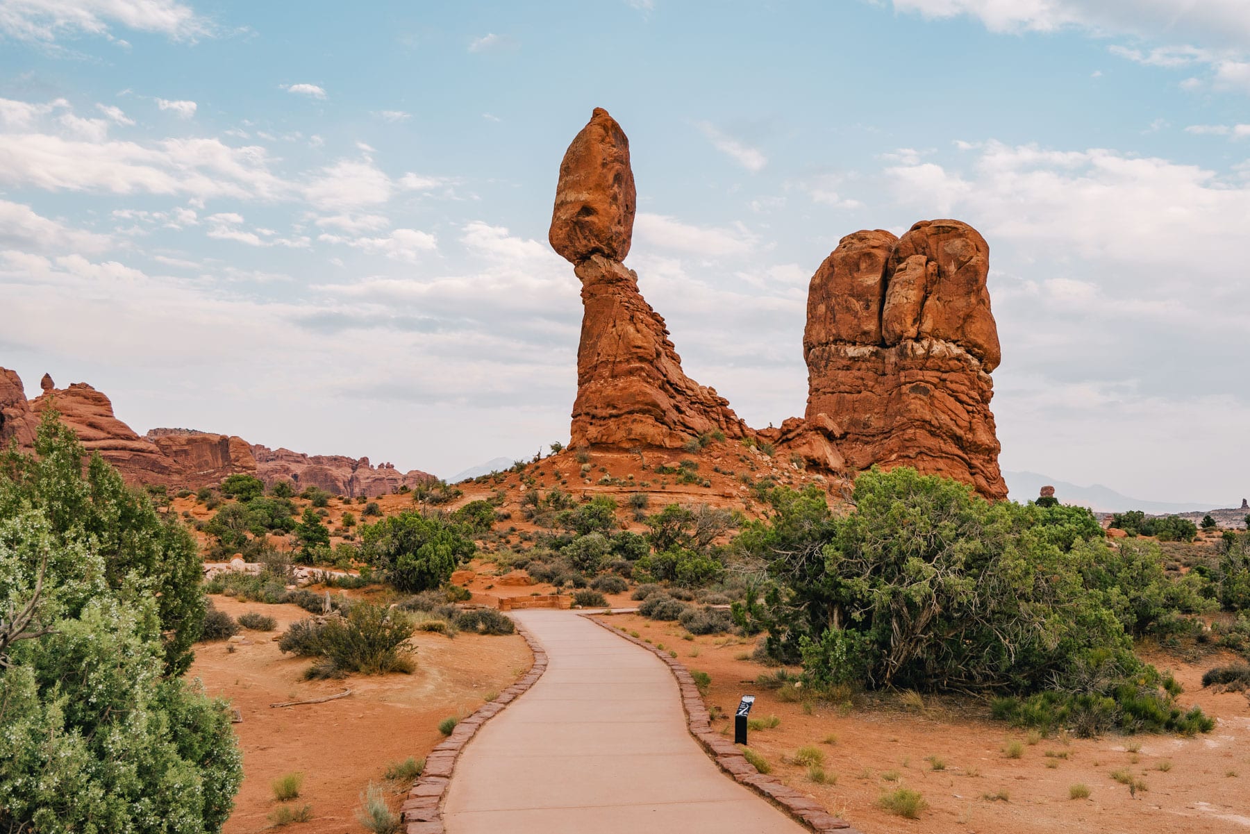
Balanced Rock Trail
- Distance: 0.3 mile
- Difficulty: Easy
- Elevation Gain: 35 feet
- Time Required: 30 minutes
Hiking the Balanced Rock Trail in Arches National Park
After Delicate Arch, Balanced Rock is probably the most flat-out iconic landform in Arches National Park. It’s just as improbable-looking as the arches: an almost unnervingly top-heavy spire, nearly 130 feet tall, which appears as if it’ll collapse at any minute.
And, heck, it could collapse at any minute: In the winter of 1975-1976, Balanced Rock’s one-time companion, a miniature lookalike called Chip Off the Old Block, did indeed topple.
Balanced Rock is readily visible from the park road, but you should definitely do the short, partially paved footpath that circles it—one of the gentlest hikes in Arches National Park. Admire how the roughly 3,600-ton hunk of Entrada Sandstone rests precariously atop its slabby pedestal composed of Dewey Bridge mudstone, which commonly forms the less-resistant bases of the park’s arches and balanced rocks.
And imagine how many eons of weathering and wind blasting have been required to set up this geologic balancing act, and how abruptly the Spire’s sandstone cap could, indeed, take a nose-dive. See it while you can! Plus it’s the easiest on our list of the best hikes in Arches National Park.
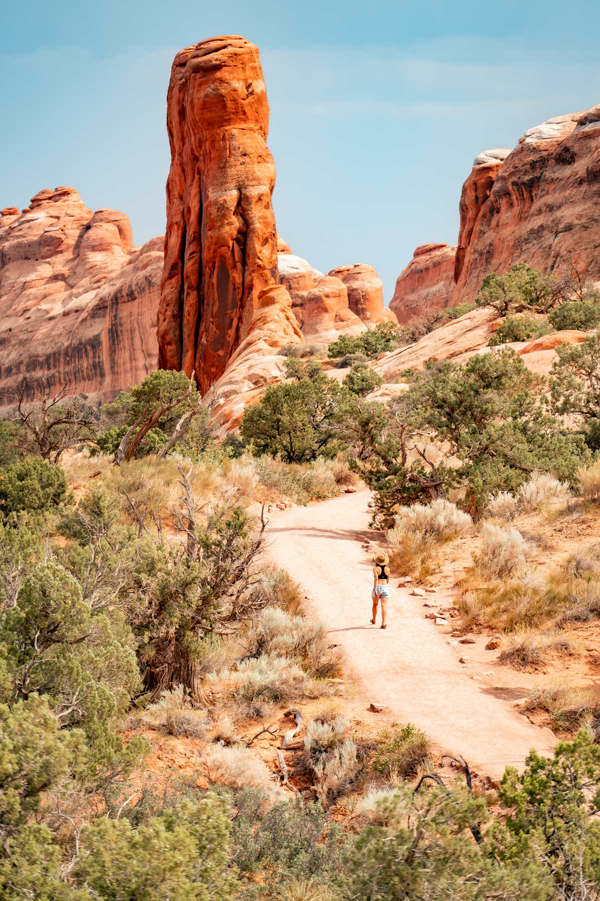
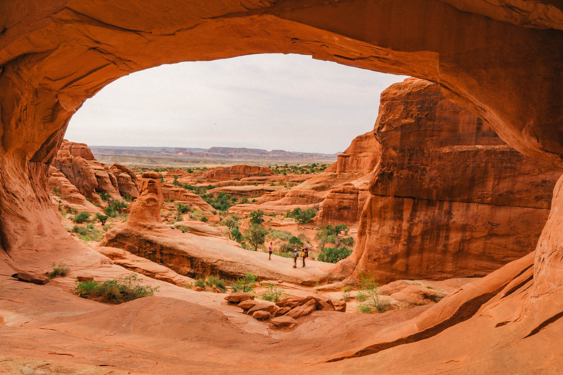
Devils Garden Trail
- Distance: 7.9 miles
- Difficulty: Strenuous
- Elevation Gain: 286 feet
- Time Required: 3 – 5 hours
Hiking the Devils Garden Trail in Arches National Park
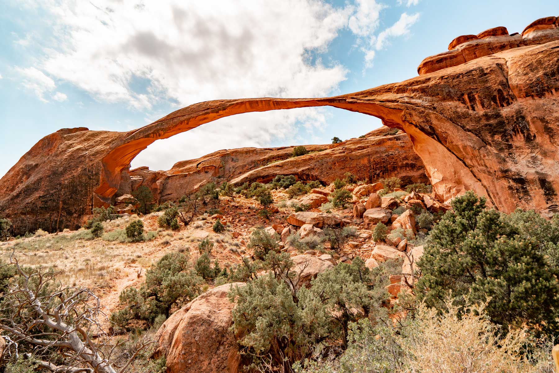
Set at road’s end in the north of Arches, the Devils Garden is a wondrous sandstone wilderness serving up some of the park’s best scenery—most of the rock arches in the park reside here, in fact—and some of its wildest ambience. I consider this as the best hike in Arches National Park.
Many visitors to the Garden content themselves with the 1.8-mile round-trip hike to Landscape Arch, but we suggest tackling the full shebang if you’re physically able: Doing so provides the deepest immersion in this special place, and shows off plenty of other eye-popping landmarks.
The “full shebang,” specifically, is essentially a lollipop loop of a trail, plus a few short spurs. It’s among the more challenging hiking in Arches National Park, with scrambling, edging drop-offs, and route-finding all involved. Follow the Park Service’s advice of bringing a headlamp (as well as—you know this already—adequate water and sun protection), just in case you tarry too long out there and find nightfall overtaking you.
Landscape Arch is the unquestioned showstopper of the Devils Garden: Its nearly 300-foot span makes it the longest known arch in North America, and among the very longest on Earth. It’s spindly for its impressive length—the lintel is as narrow as six feet across in places—and a prime example of an arc natural arch.
Those hoofing it along the entire Devils Garden Trail can also admire other awesome arches—Pine Tree, Tunnel, Navajo, Partition, and Double O among them—as well as the hundred-foot obelisk called Dark Angel.
Delicate Arch Trail
- Distance: 3 miles
- Difficulty: Moderate
- Elevation Gain: 480 feet
- Time Required: 2-3 hours
Hiking the Delicate Arch Trail in Arches National Park
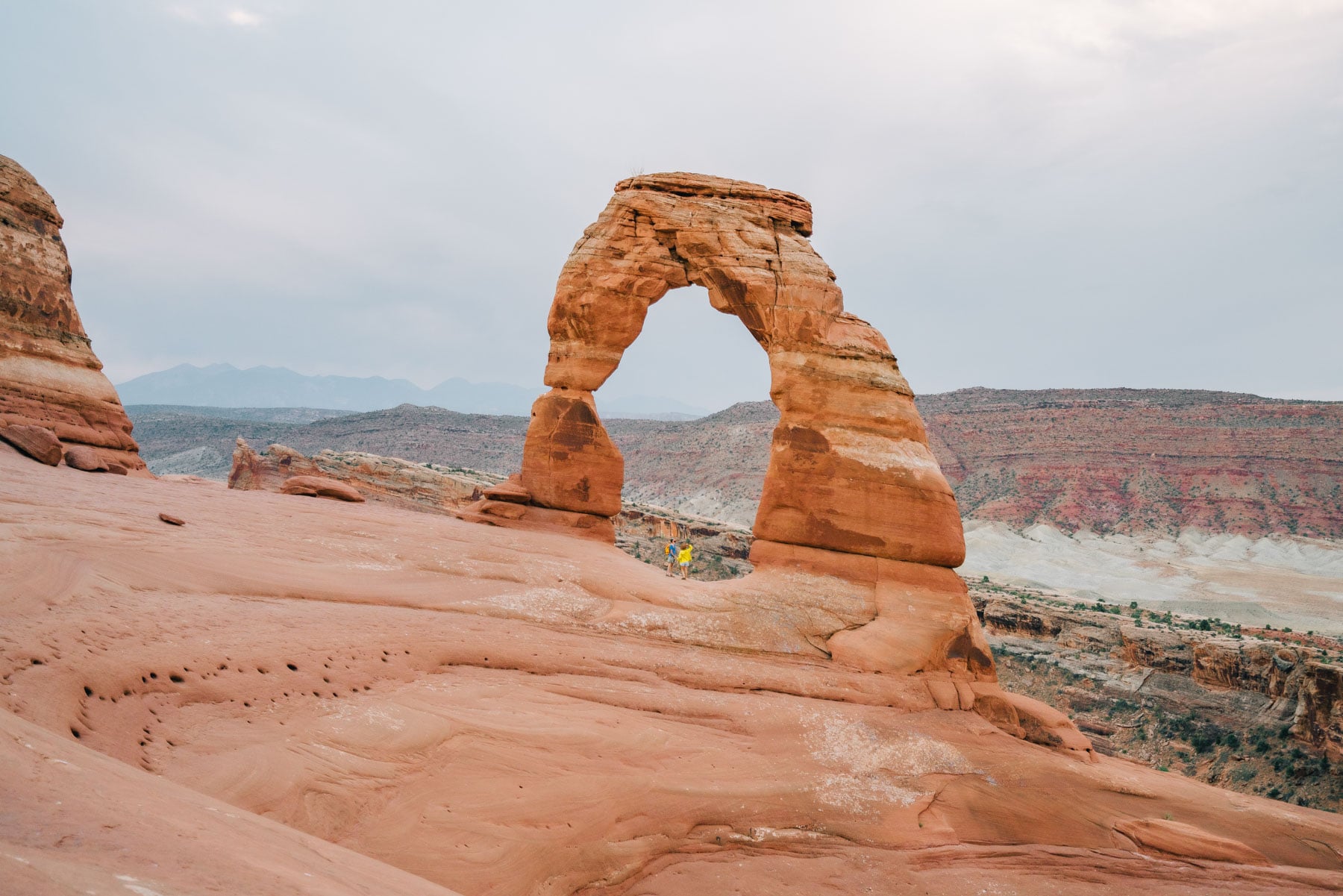
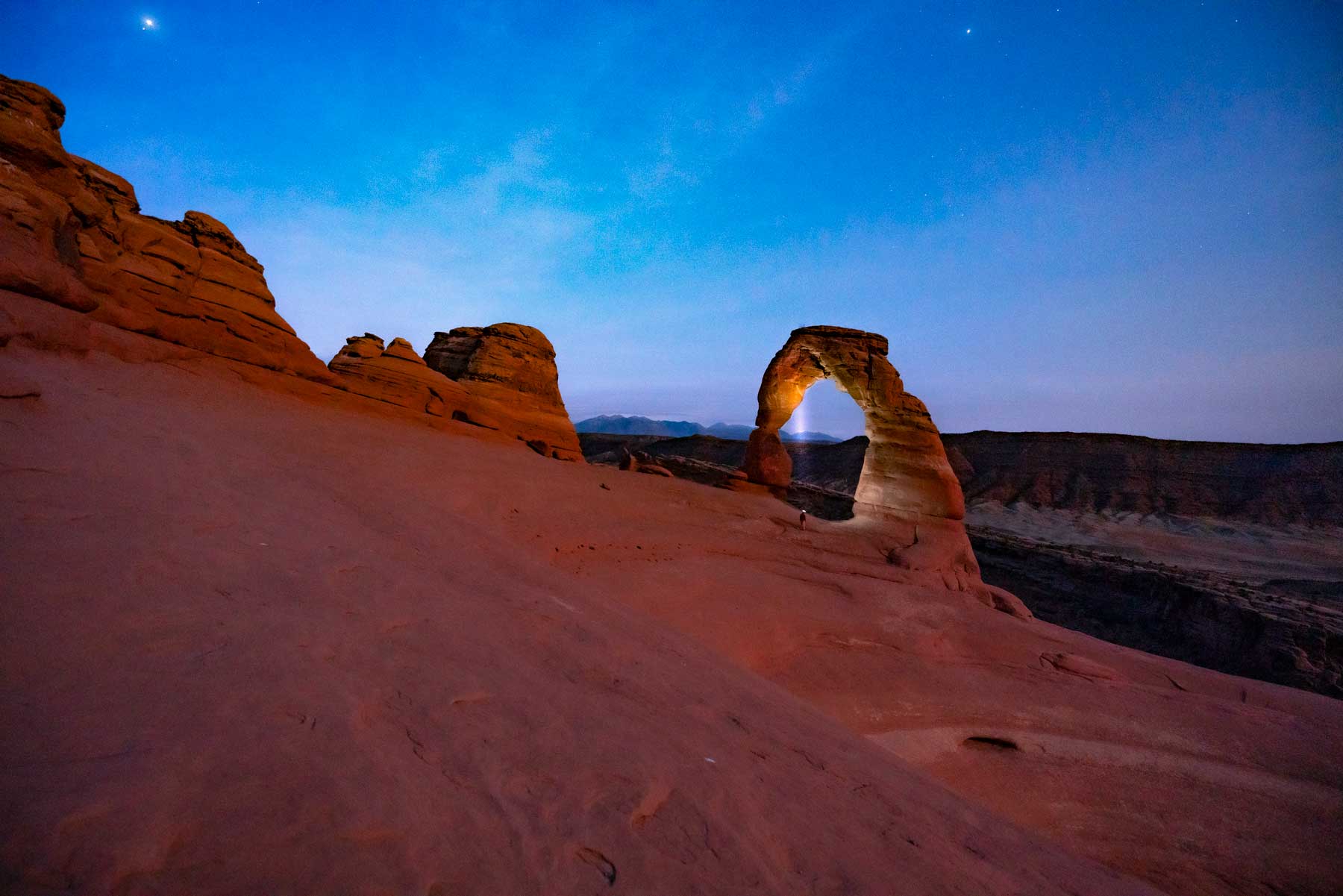
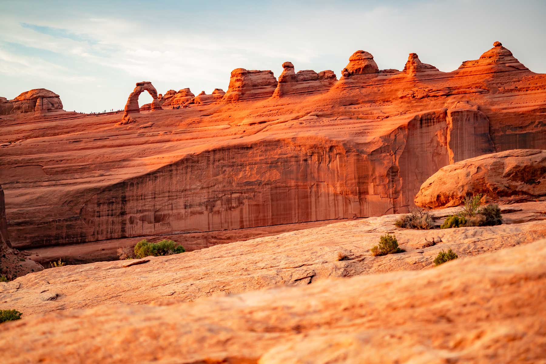
Delicate Arch may be the most famous landform in Utah. For many, in fact, the sight of this biggest of Arches National Park’s free-standing arches epitomizes the otherworldly beauty of the state.
All things considered, it’s hard to list Delicate Arch anywhere but the top of any list of the best hikes in Arches National Park—and that’s partly this signature feature can really only be seen in all its glory from the trail, given the viewpoint from the roadway corridor shows Delicate Arch from a mile off.
Hikers willing to take the Delicate Arch Trail, which starts at the Wolfe Ranch trailhead, can appreciate up close this stunning natural sculpture, which stands some 85 feet tall and 65 feet wide, with a roughly 46-by-33 feet opening. Its lower portion is formed of the Slick Rock Member of the Entrada Sandstone, with the upper part of the arch representing the Moab Tongue Member of the Curtis Formation.
Beyond Delicate Arch, Dry Mesa looms, with the La Sal peaks on the horizon: a simply glorious arrangement of rock and sky, and one of the quintessential vistas on the Colorado Plateau. Not long before you reach Delicate Arch itself, you’ll pass Frame Arch: so-named because its window affords an especially photogenic perspective of Delicate.
Expect company along this trail, though winter hikers have a chance at solitude. Delicate Arch is especially popular at sunset, given the low-angle, day’s-end sun flares up its sandstone to magical effect. That’s worth seeing, for sure—and sunset’s one of the smarter times to hit the trail, especially during southeastern Utah’s hot summers—but you may well enjoy this hike during a less-popular window.
The trail includes a fairly steep climb up bare slick rock, and the final approach to the arch involves traversing a ledge. The main challenge, though, is the exposure to the sun: Make sure you’ve got plenty of water and a good sun hat, and take frequent breaks.
Upper Delicate Arch Viewpoint Trail
- Distance: 1 miles Round Trip
- Difficulty: Easy
- Elevation Gain: 100 feet
- Time Required: 10-20 mins
Hiking to Upper Delicate Arch Viewpoint
This one is just a bonus throw in because the viewpoint is really spectacular and it’s a great way to escape the crowds. Instead of hiking the main trail to Delicate Arch, there’s a separate trail from the lower parking lot that leads to the Upper Delicate Arch Viewpoint.
I love this as one of the best easy hikes in Arches that packs a punch. Sunset from here is much better than at Delicate Arch and you might be the only people there.
Map of Best Hikes in Arches National Park
FAQ – Best Hikes in Arches National Park
The most popular hike in Arches National Park is the Delicate Arch hike which features the state’s most famous natural arch.
Delicate Arch is rated as a moderate hike in our book with just 480 feet of elevation gain over 3 miles. Footing is not the most stable so those with mobility issues should opt for the Lower Delicate Arch Viewpoint instead.
Summary of the Best Hikes in Arches National Park
- Delicate Arch Trail
- Devils Garden Trail
- Balanced Rock Trail
- Double Arch Trail
- The Fiery Furnace
- Park Avenue Trail
- Tower Arch Loop Trail
- The Windows Loop Trail
- Broken Arch Loop
- Courthouse Wash Panel Trail
- Eye of the Whale Arch Trail
- Skyline Arch Trail
Pin the Best Hikes in Arches National Park


best hikes arches national park, best hikes in arches national park, hiking in arches national park, best hikes arches national park, best hikes in arches national park, hiking in arches national park, best hikes arches national park, best hikes in arches national park, hiking in arches national park, best hikes arches national park, best hikes in arches national park, hiking in arches national park, best hikes arches national park,
Helpful Related Articles
Things to Do in Arches: 17 Best Things to Do in Arches National Park
Best Hikes in Arches: 12 Best Hikes in Arches National Park
The Narrows Hike in Zion: The Narrows Hike in Zion Isn’t For You. Here’s Why.
Angels Landing: Complete Guide to Hiking Angels Landing
Things to Do Canyonlands: 20 Epic Things to Do in Canyonlands National Park
Things to Do Bryce Canyon: 20 Epic Things to Do in Bryce Canyon National Park
Things to Do in Zion: 18 EPIC Things to Do in Zion National Park
Road Trip Essentials: 35+ Road Trip Essentials (You’ll Love + Packing List)
Road Trip Planning Tools: 15 Best Free Road Trip Planning Tools (& Apps) 2022
Zion National Park Guide: Ultimate Guide to Zion National Park
Best Hikes in Zion: 16 EPIC Hikes in Zion National Park
Utah’s Manti-La Sal National Forest: Manti-La Sal National Forest: The Forest As Beautiful as Utah’s Parks
Utah National Parks Guide: 5 MIGHTY Utah National Parks Guide
Utah National Parks Road Trips: 5 Best Utah National Park Road Trips
National Parks Rankings: ALL 63 US National Parks Ranked By Experts
Most Visited National Parks: Top 10 Most Visited National Parks
Least Visited National Parks: Top 10 Least Visited National Parks


As fellow fans of our National Parks, we thought you might like our new artwork of Arches NP.
Thank you and best regards.